Day 8 - 15 some update to day 15 ...
 nature is beautiful
 some good marking of the trail made it a great experience
  10 min's to reach destination, those signs you start lovin' after all the meters up the mountain
Anyway... Day 8:
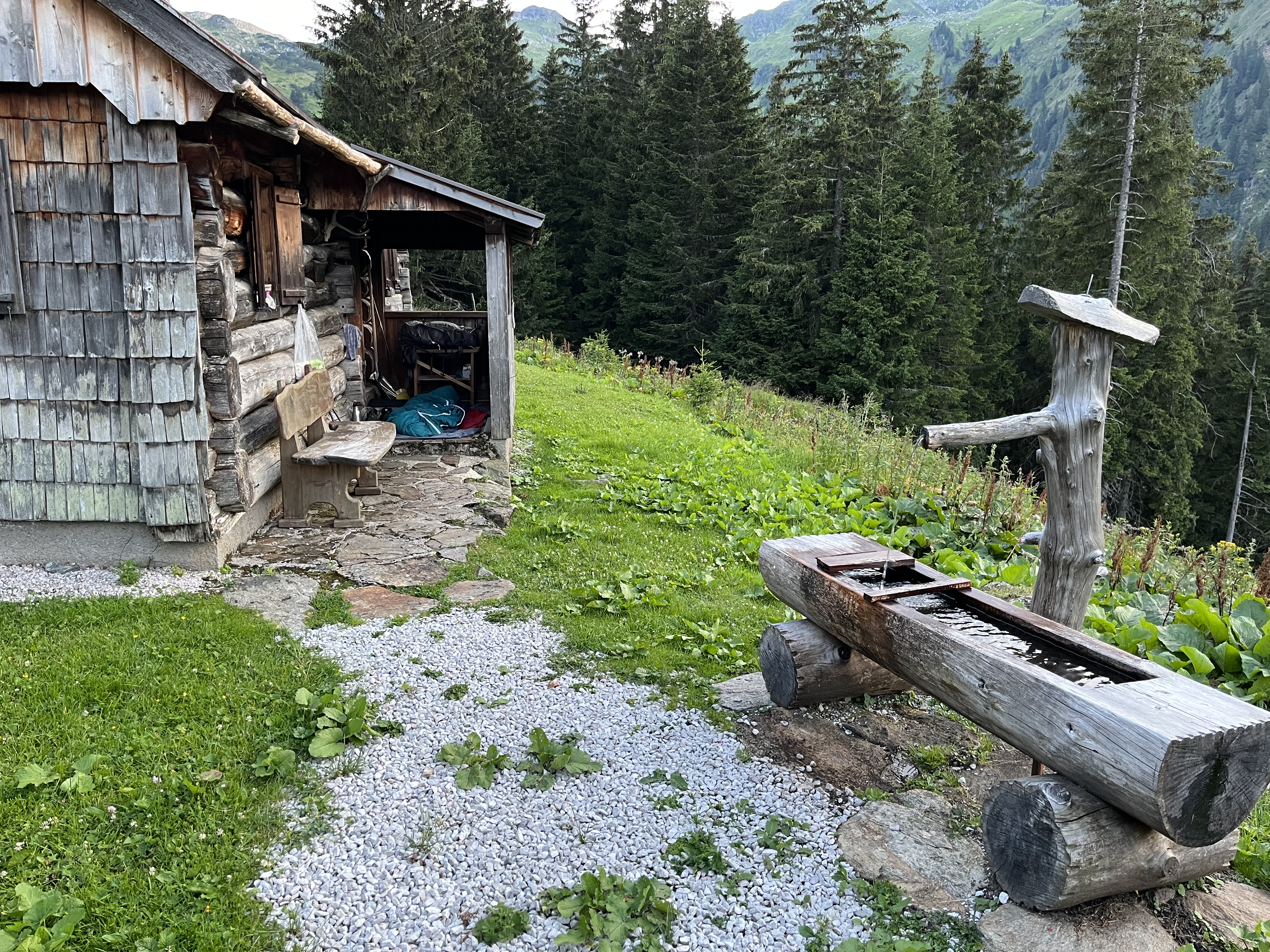
Graf Meran Haus to Voisthaler hut. The hut was not to stay... the atmosphere in the hut was as the weather. all we got for breakfast was marmalade and some bread but better than nothing so we started the day. it was storm wind and rain outside and tried to make our hike down back into the valley it took us a while to go below the clouds but then it cleared up more and more and the second half of the day ended up with a great hike to Voisthaler hut. The hike up was enjoyable lots of nature and animals around

Wild Capricorns near Voisthaler


 On our way to Voisthaler Hütte
Day 9
Schiestlhaus - Hochschwab- Sackwiesensee - Sonnenschien Hütte
 weather was promised to be good for a peak, so we started early from Voisthaler for the detour to catch the peak. Expecting the weather to clear until lunchtime...
 Capricorns on our trail again
 approaching Schiestlhaus for a short break, the weather forecast wrong again, no sense at all to climb the peak
We waited for Andy and Marie and continued the hike into storm, fog and icy rain, down to tree regions and to the Sonnenschien Hütte (sunshine hut)
But first the Hochschwab peak:
 Keep Smiling!
Hochschwab peak 2275m, 5°C, storm and some frozen rain.
We still made it on top of the Hochschwab… call us crazy… but it was indeed the easier hike to continue our route. With sunshine it would have been a 15 minute walk from the hut to the peak, and we got the promise with really great views all around. Indeed a few days later I have seen this peak looking backwards, need to find the picture...
 a safety Biwak hut near Hochschwab, appers to be worth it as this weather shows, in our xase the fog was clear enough to see next signs to make our way, else we probably would have used it to wait for a weather clearance.
After about 8 km we finally got below 1700m and it cleared up a bit, wind got less and it stopped raining...
 clouds are clearing up at last crossing to reach sunshine hut
Day 10
Via Leobner Hütte to Eisenerzer Reichenstein and the hut close to peak
Indeed the hut's name (sunshine hut) seemed to work, weather was clearing up for the day. Three of us set the goal to reach the Reichenstein peak and stay the night at Reichenstein hut close to the peak.
 Clearing clouds at Leobner
We started hiking into a day that lost the clouds more and more, a great hike along the tree level, sunshine and clouds, just a great day for hiking. Around lunchtine we reached a small hut (Leobner) that served a great soup.
The hike continued and finally challenged us with the Reichenstein peak, we had to go up from below 1500 to 2100m, just o the last few kilometers, to end of day a little challenge to my "office chair " knees. The trail was easy, but at about 2000m we met the clouds again. It seemed the oeak collected them to hude from us. Was quiet interesting to walk into it. Temperature dropped right away and a fresh moustirex wind grapped our bodies. We where happy to reach the last sign " 5 minutes to the hut".
 Kasspressknödel - soup with view @ Leobner hut
 nice day on our way to Reichensteiner hut near the peak in the middle of the picture
 the Reichenstein hut in the clouds 2128m
 clouds and sun dancing with each other at 2100m
Day 11
Reichenstein down to Eisenerz / Radmer
 leaving Reichenstein, it appeared to be not a really good idea
Original plan was to stay on a line of peaks at around 2000m for two days and approach the Mödlinger hut directly without a valley dive... the weather had a different opinion.
We climbed some rope secured parts of the trail, stormy, all wet, no good view, so decided to stop that idea. But instead of returning to the hut we decided to take a side pass down into the valley. It was an unmarked Trail and in reality there was not even a trail. that made it quite a challenge
 finding our way only with GPS no marks, no visible trail anymore, quiet a dangerous game, we three agreed afterwards it was a no sense story, and we should have returned to the hut. Luckily nothing happened. And we got out of storm and clouds, just soaking wet from head to shoes.
 getting below the clouds
 last steps to the forest trail... we luckily made it down the non existing trail. Experience and good equipment...and a portion of luck I guess
Finally down in the valley near Eisenerz, we continued our path on normal forrest trails, getting wet every half hour or so... and luckily met Andi and Marie again ...the team is joining again for a while to do sone hiking trough the rain. At the end of day we where all just happy to reach a hostel that served some great food and had a hot shower for us. They even made it happen that our shoes were dry again next morning
Marie, Andi, Philipp, Dominik, it was a pleasure to hike with you! Indeed it was the kast evening with the five of us
Day 12
Radmer to Mödlinger Hütte
Philip and Dominic join me on that day trip to Newton Hut was quite a nice hike the weather was good, the sun came out, trsil was not too steep and everything was great again.
 what else do you need?
 Mödlinger hut in the evening, we decided to sleep outside and watch the stars, as the weather finally appeared to be nice

Day 13
Mödlinger Hütte to Hohentauern , rest for a day
It was an easy walk down to The Valley, Gaishorn am See was the small village, and indeed it had a small shop and a lake, so I catched some fresh food and enjoyed a relaxing half day at and in the lake. Challenge was that I had another 12 km and some 600m up into the mountains to do to reach the finish line of my first quarter.
Plaa was to stay three nights in a small hotel with a sauna and relax for some time.
Day14 rest... It was completely boring… and writing a blog all day long… not on a tablet 🙈
Day 15
So instead of hanging out there for another day, I packed my bag and at least continued to the next hut in the mountains, but it was so crowded with all kind of people, and weather forecast was so fantastic… I climbed up into the mountains and catched the highest peak in that region in late afternoon:
 highest peak so far 2448m "Großer Bösenstein, highest in that region.
What an anazing view
Then I just started the next trail instead of sleeping at the hut. I continued to travel along the central alp trail, my plan for next three days, and found a great place again to sleep under the stars

A spot for the night somewhere on the CAT
Day 16 ZAW 2
 what did you do on that sunday afternoon? I had a rest with a view
Creating ablog on a tablet with my thick fingers is a mess and takes far more time than expected.
So stay tuned for more to come when I have connectio again
Everything from here is a draft ..
Day 17 ZAW 3
Day 18 Talkenschrein - Mössna
Day 19 Break and blog
Day 20 Mössna to Sonnenscheinalm
DAY 21 To Ritzingerhütte
With a warm soup we could watch the clouds and sun playing with each other in the evening.
In the valley we saw a pile of fire wood on the way, and a sign to pick a few up and carry it to the hut... so we did and got agood Obstler for it... and a warm oven...


 up again on trail 918, final part of this trip over the shoulder into Sölk-Tal
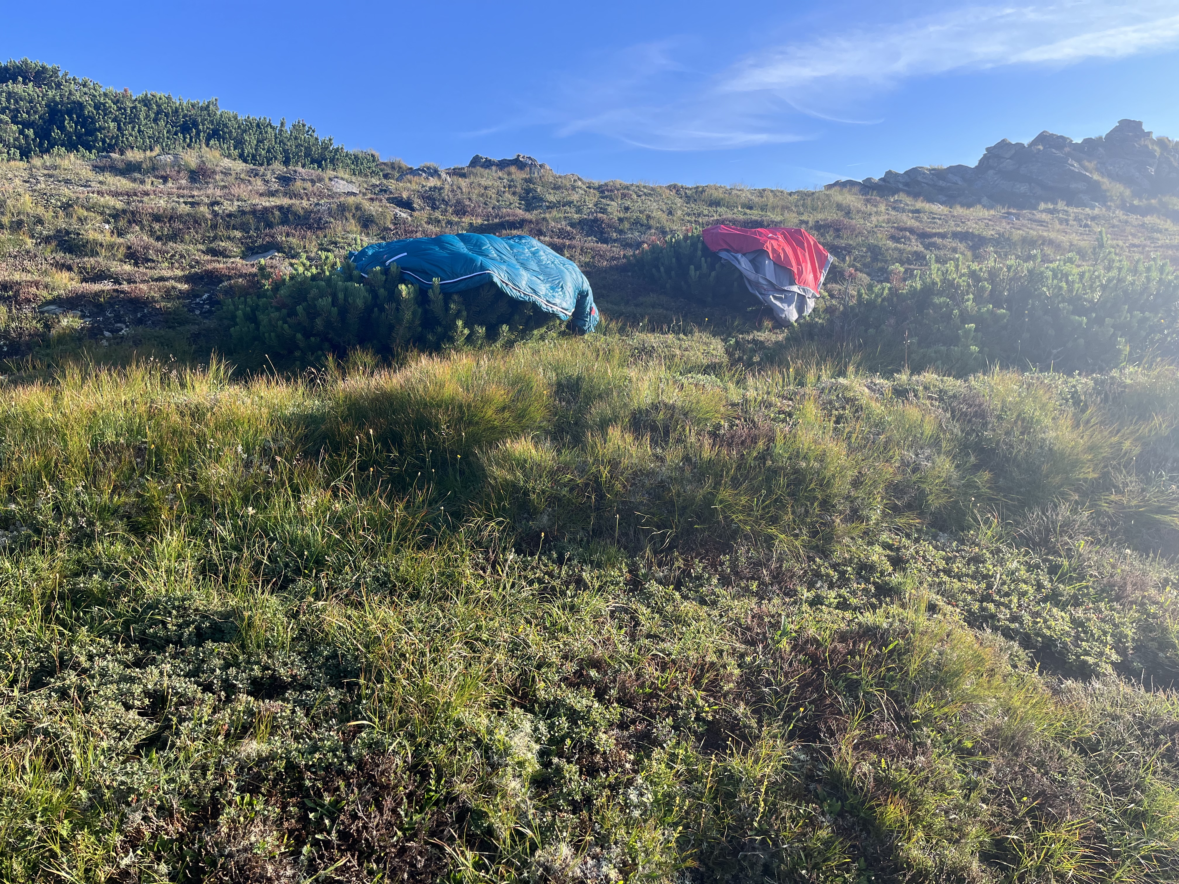 drying the sleeping bag in the morning sun, it’s cold up there on 1900m
 Gaishorn lake, time fo a nice swim
 good night view on the ZAW
 Großer Bösenstein with a great late afternoon view
 just one of those views, an untouched nature reseve since 2000
 This is when you can just continue hiking forever
 good bye hut and lake... on my way to Bösenstein peak
 down in the valley... WATER


 steep hike up into the sky

Comments
Post a Comment